PLL Back in Fairfield For Another Go-Around
Lacrosse fans everywhere were overjoyed when the Premier Lacrosse League
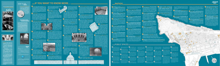
Fitting five centuries and a city in 18”x 30”
The New School of Architecture of the Polytechnic University of Puerto Rico, with a grant from the American Express Foundation, produced an architectural map of old San Juan, the first of to identify both its structures and public spaces including its patios, nooks and other hidden spaces. The map –edited in Spanish and English- is geared to a wide range of audiences including children, tourists and those who know and have studied the city.
For too long the historical center of our capital city has lacked a guide that explains to the public the history and merits of the buildings within the walled district. Conscious of this need, Polytechnic University took on the task of documenting San Juan’s colonial heritage, drawing and photographing some of the best examples. Students and professors have developed detailed drawings and informative texts that are included in the map/guide. With the map, visitors to the city can walk through Old San Juan at their own pace and define their visit individually.
Map designed to inform the visitors of Old San Juan of important inner spaces that are not visible from the sidewalk or street.
Activity made to present the map and its contents to several schools in the area of Old San Juan.
A series of faculty members of the Architecture school of the Polytechnic University of Puerto Rico provided tours, teaching about the importance of each of the spaces.
Marker designed to identify those building that inside have an open space.
Lacrosse fans everywhere were overjoyed when the Premier Lacrosse League
Filmed and edited a visual story to celebrate the company’s
Meet Catholic Sisters Vicky and Brenda of the Misioneras del